|
Article by Sea Grant
Great Lakes charter boat captains are in the business of finding fish. They take recreational anglers out on the lakes, finding spots with the highest likelihood of landing a great catch. So how do they know where to go? Do they have a crystal fish ball? Though many captains have years of experience on the lakes, they also rely on technology to pinpoint specific locations. Many captains use websites like the Great Lakes Observing System (GLOS) or CoastWatch to obtain maps with Great Lakes surface water temperatures. They know that, because fish are cold-blooded, they are very dependent on the environment and particularly water temperatures. Other certain environmental factors also dictate where fish feed. Grade Levels:
Performance Expectations:
OBJECTIVES
BACKGROUND Steelhead trout belong to the family Salmonidae that includes all salmon, trout and chars. Steelhead are born in freshwater streams, where they spend the first years of life. They then swim out to the ocean or one of the Great Lakes where most of their growth occurs. Steelhead are also known as rainbow trout. However, they are typically called steelhead when they spend most of their lives in the open waters of the Great Lakes. Their life cycle is similar to that of Pacific salmon. Steelheads are indigenous to the Pacific coasts of North America and Asia, and have been successfully introduced to inland lakes like the Great Lakes. After spending between one to four growing seasons in the ocean or lake, steelhead return to their native freshwater stream to spawn. Though they are not native to the Great Lakes, Lake Michigan steelhead live a life that is very similar to that of their ocean-going relatives. Lake Michigan serves as a substitute for the ocean and they return to spawn in tributary streams. Steelhead in Lake Michigan – What Anglers Need to Know Think about being a charter captain or someone on the hunt for steelhead in Lake Michigan. What are the basics you should know? Scientific Name: Oncorhynchus mykiss. Members of the Salmonidae family include salmon, trout and char. Also called rainbow trout. Identifying Characteristics: Two dorsal fins, including an adipose fin, light-colored mouth and gums, small spots on tail. Average Size: Growth varies greatly, even within the same population. Mature fish are typically 16 inches in length and about 9-10 pounds, but may reach 36 inches and up to 20 pounds (40 centimeters and 4-5 kilograms, up to 91 centimeters and 9 kilograms). Lifespan: Typically 6-8 years in the Great Lakes region. Habitat: During the lake-dwelling portion of their lives, steelhead are often found in waters less than 35 feet (11 meters) deep with temperatures of 58-62 degrees Fahrenheit (F) or 14-17 degrees Celsius (C). In the spring and summer, steelhead are often found near stream outlets prior to moving upstream to spawn. Life Cycle: Steelhead mature in 3-5 years. Most steelhead return to their home stream — the stream in which they were born or planted — to spawn. Unlike Pacific salmon, steelhead in the Great Lakes do not necessarily die after spawning and are able to spawn more than once. A steelhead may spawn several times during its life, although most only spawn once or twice. Steelhead in the Great Lakes enter spawning streams between late October and early May. Most spawning occurs in the spring, with the peak of spawning occurring in mid-April. Eggs hatch in 4-7 weeks. Young steelhead, called parr, typically remain in their home stream for 1-3 years before migrating to the lake. Diet: Young steelhead feed on zooplankton and aquatic insects. During the lake-dwelling portion of their life cycle, steelhead eat small fish and insects. Steelhead feed primarily at mid-depths (the middle of the water column), but will also feed on surface insects. Feeding Strategy: Compared with salmon, steelhead have a slow attack speed. This makes them less-than-efficient predators of quick fish such as alewives and smelt. While most salmon are quick and efficient predators and can successfully hunt schools of small fish closer to shore, steelhead move to deeper waters to feed on an accumulation of bugs and slower fish, such as sticklebacks. Predators: In the Great Lakes, sea lamprey are the most common predator of all salmonid species. Other predators include: larger fish, fish-eating birds such as great blue heron and kingfisher, and mammals such as mink and raccoon. Reading the Cues Aquatic habitats are defined by environmental factors. If you know what to look for, these factors can provide clues to help find the best fishing spots. For example, fish prefer habitats that are within the fish’s optimal temperature range and provide access to food. Due to interactions of abiotic factors such as temperature, oxygen, pH level, light, nutrients, pressure, substrate and circulation, aquatic life is not evenly distributed, i.e., it is patchy and variable depending on the other influences at play. Anglers report better catches at thermal fronts than in nonfrontal regions — movement of steelhead in open water seems to be associated with thermal fronts. Thermal fronts are where water masses with significantly different temperatures meet or interface. This interface is a region where water temperatures rapidly change and are often abundant with aquatic life. Thermal fronts can offer both optimal temperatures and access to food. The range of temperatures and abundant food at thermal fronts can be clues to help you find steelhead and other fish in the Salmonidae family.
Upwelling
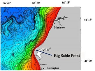
Later in the season, fishing is influenced by thermal fronts and water temperatures associated with upwelling:Figure 3. Upwelling and Ekman Transport Diagram (source: American Meteorological Society) Upwelling occurs when strong winds push away surface waters allowing deeper, colder waters to rise to the surface. A good example is near Big Sable Point in eastern Lake Michigan (north of Ludington). Upwelling occurs near the shore caused by strong winds from the east, northeast or northwest — any wind that moves the nearshore water offshore or any prolonged wind that causes a strong north to south current. The bathymetry near Big Sable Point contributes to a cold-water upwelling associated with strong winds from the east, northeast or northwest. Near Big Sable Point, Lake Michigan becomes very deep just offshore. As warm surface waters are pushed away by winds, colder bottom waters ‘upwell’ to the surface (Figure 4). Deep waters nearshore at Big Sable Point are key. As warm surface waters are pushed away by the wind, deep cold waters near shore upwell to the surface (see Big Sable Point bathymetry). South or southwest (or even straight west winds) cause warm water to ‘pile up’ in the bay. Under these conditions, warm waters will be found as deep as 150 feet or more (typical depth of warm water is 60-70 feet). Temperature is less of a fish-catching factor as summer becomes fall, because fish enter river mouths and many move upstream. 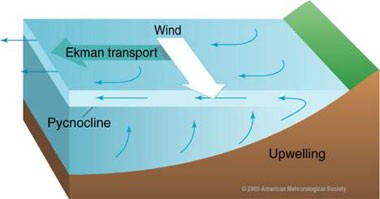
So what does all of this have to do with catching steelhead? Prey is often abundant at thermal fronts and fish in the family Salmonidae, particularly steelhead in eastern Lake Michigan, seem to be attracted to spring thermal fronts to feed on insects that originate on land (terrestrial) rather than the water. (We know this because researchers found that terrestrial insects were abundant in steelhead stomachs in the spring.) Accumulation of these insects is thought to be related to the eastern central Lake Michigan shoreline. Insects along steep, sandy cliffs are caught in rising air currents, and as the air cools over colder lake waters, they are deposited into the lake, essentially raining down food for steelhead and other fish. HOW TO FIND FISH IN LAKE MICHIGAN Knowing this, how can we apply it to find fish? Commercial, subsistence and recreational fishermen use surface water temperatures and visual clues to find thermal fronts. How to detect water surface temperatures:
Learning about Great Lakes surface water temperature contour maps:
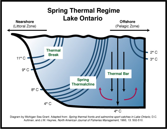
In the spring, fishing is best at thermal bars nearshore. Look for tight contour lines following the shoreline with a 10-degree temperature change over the course of the lines. Fishing is best in the area outside of the series of contour lines. Thermal bars may be present until mid-June or possibly early July. When waters reach 60 degrees F, thermal bars no longer form. In the summer and early fall, fishing is best at upwelling areas. Look for rings of cooler water nearshore. (Offshore rings are likely errors related to clouds. The bathymetry and currents in Lake Michigan do not support offshore upwelling.) Fish Finders – Lesson 1: Fish_Finders_Lesson_1 ACTIVITY
LESSON SOURCES CoastWatch. Great Lakes water temperatures. Michigan State University (MSU) Remote Sensing and GIS Research and Outreach Services in East Lansing, Michigan, NOAA Great Lakes Environmental Research Laboratory and Michigan Sea Grant. Supported by MSU College of Agriculture and Natural Resources and MSU Extension. Accessed December 4, 2009. Spring thermal fronts and salmonine sport catches in Lake Ontario. 1993. North American Journal of Fisheries Management 13: 502-510. Authors: Aultman, D.C. and J.M. Haynes. Food of trout and salmon in Lake Ontario. 1986. Journal of Great Lakes Research. 12:200-205. Author: Brandt, S.B. Fact sheet explaining latitude and longitude. 2007. Institute for Fisheries Research, University of Michigan School of Natural Resources and Environment and Michigan Department of National Resources. Author: Geddes, C. Springtime steelhead produce great fishing action. 2006. Michigan Department of National Resources and Environment. Website accessed December 4, 2009. Water on the Web: Monitoring Minnesota Lakes on the Internet and Training Water Science Technicians for the Future – A National Online Curriculum using Advanced Technologies and Real-time Data. University of Minnesota-Duluth, Duluth, MN 55812. Authors: Munson, BH, Axler, R, Hagley C, Host G, Merrick G, Richards C. Website accessed December 1, 2009. DATA SOURCES Big Sable Point bathymetry. Coastwatch. Great Lakes water temperatures. Michigan State University (MSU) Remote Sensing and GIS Research and Outreach Services in East Lansing, Michigan, NOAA Great Lakes Environmental Research Laboratory and Michigan Sea Grant. Supported by MSU College of Agriculture and Natural Resources and MSU Extension. HarborView. Great Lakes observing system (GLOS) and University of Wisconsin Sea Grant extension program. Author: David Hart University of Wisconsin Sea Grant extension program. National Oceanic and Atmospheric Administration (NOAA). National Data Buoy Center. US Department of Commerce, NOAA, National Weather Service, National Data Buoy Center, Stennis Space Center, MS National Oceanic and Atmospheric Administration (NOAA). On-line Chart Viewer. NOAA Office of Coast Survey. Michigan Sea Grant helps to foster economic growth and protect Michigan’s coastal, Great Lakes resources through education, research and outreach. A collaborative effort of the University of Michigan and Michigan State University, Michigan Sea Grant is part of the NOAA-National Sea Grant network of 34 university-based programs. B.C. fish processors spewing potentially dangerous bloodwater into key salmon migration corridor.12/2/2017
Quite scary how the government is willing to risk such a key element of the ecosystem to fish farming!  by Steve Galea | February 21, 2017
Recurring issues of illegal or poor angling behaviour that include littering, alcohol in public places, and wastage of fish have caused the Municipality of Port Hope to consider implementing night fishing restrictions and a $40 Municipal Access Fishing Pass. The proposals apply to stretches of the Ganaraska River owned by the Municipality or the Ganaraska Region Conservation Authority. These proposed resolutions will be presented to the Municipality of Port Hope Council on Feb. 21. The report recommends petitioning the Ministry of Natural Resources and Forestry (MNRF) to revise the Ontario Fishing Regulations to “prohibit night fishing on the Ganaraska River from August 15 to September 30, from 8 p.m. to 6 a.m., from the Robertson Street Bridge to the Jocelyn Street Bridge; And further, that By-law 45/2012, being a By-law to regulate, protect and govern the use of Parks, Recreation Areas and Park Facilities be amended to prohibit night fishing on the Ganaraska River from August 15 to September 30, from 8 p.m. to 6 a.m., on all Municipal properties from the Robertson Street Bridge to the Jocelyn Street Bridge…” Another proposed resolution calls for the creation of a Municipal Access Fishing Pass, for anglers between 18 and 65. It would permit fishing in municipal and Ganaraska Region Conservation Authority properties. The report containing the recommendations cites poor angler behaviour that includes “snagging, gaffing, and netting of fish, fishing in a sanctuary, harvesting roe, leaving remains to spoil, fishing without a valid license, and keeping more than the daily limits.” It also asserts that much of this behaviour occurs during the night. The report notes that the MNRF are not supportive of the Access Fishing Pass as it might restrict access to public fishing and set a precedent for other jurisdictions to follow suit. Ontario Federation of Anglers and Hunters Fisheries Biologist Tom Brooke said, “We’re aware that there are issues with fishing at Port Hope and that something needs to be done, but we are hoping that the Municipality would consider options that don’t restrict access to the fishery.” Brooke says public parking fees in the area or the licensing of food vendors who would serve anglers are two possible solutions. These would help the municipality recoup costs (which are reported to be almost $20,000) incurred from running and maintaining their fish cleaning station and porta-potties along the river. Jim McCormack, Director of Parks, Recreation and Culture for the Municipality of Port Hope said, “We had to do something. We as a Municipality are incurring costs in order to deal with fishing issues. The numbers of anglers are overwhelming, especially on weekends in the fall, and with that comes an overwhelming number of issues.” McCormack says the Municipality has trained members of the Port Hope Police Services to enforce fisheries regulations and have also introduced a zero-tolerance policy for violations. He says this has helped, but it is costly. “All the tickets we write for fishing violations go to the province and we are not recovering costs, so these proposals address that and the other issues.” He says that should the proposals be approved by council, by-laws and processes will still have to be developed. “We want to make this a smooth transition.” Because of this, should the proposals be approved, McCormack believes the changes will not be in place until autumn 2017. The Ganaraska River is the most-fished tributary on the north shore of Lake Ontario. The Municipality is seeking public comment on the issue until February 26. To learn about the issue and comment visit http://www.porthope.ca/community-consultation/salmon-fishing-report. Although we won't be at the show this year promoting Nomad or OKFS, this is still the best fishing show in Canada to attend. Get out and support our local businesses and guides!  Maybe see you wondering around the show.
A cool Fall day in Dec '16. Fishing was a bit slow for the first half of the day but was able to round it out with three steelhead each from different year classes, which was great to see and very important for the fishery! Time for a new camera angle though, so stay tuned for the next videos. Unfortunately we occasionally get reminded of this topic due to an incident. Today's reminder is another example of just that.
2013 ICAST Best of Show winner with the release of the Predator 13, Old Town finally takes the NEXT step in kayak fishing evolution with the release of the Predator PDL. Following the success of the Predator 13 and MX, two of the best paddle fishing kayaks on the market, Old Town is on the cusp of kayak fishing supremacy with their boat line-up.
With several other companies moving into the pedal drive bracket, there will be numerous options available at a wide range of pricing. After many years of being stuck with the only game in town, kayak anglers now have a lot of options. Do your homework to be sure you get what is best for YOU.
At Nomad Adventures, our choice is simple... go with who makes the best of both worlds paddle & pedal: Old Town Kayaks! |
FISHING NEWS ONTARIOOntario and Great Lakes region salmon, steelhead, and migratory trout fishing articles, information, news, and reports. Stay up to date on our most recent trips, events, tournaments, and general news on adventure fishing and kayak fishing in Ontario and Canada. 
Archives
April 2021
Categories
All
Links |
 RSS Feed